Friday, May 27, 2011

[Vesti] The Telegraph : Otmica Persefone na aukciji

A Marble Persephone From the Marques

Several months ago Florent Heintz, head of Sotheby’s antiquities department, consigned a Roman marble sarcophagus panel from about A.D. 190-200 for his June 8 auction in New York. There were no good photographs of it, but the panel was known to scholars even if its whereabouts were unknown for more than 30 years.
The panel, which depicts the rape of Persephone, comes with an interesting provenance. Beginning in 1776 it belonged to William Petty Fitzmaurice, the second earl of Shelburne, later first marquess of Lansdowne, who displayed it in the ballroom of Lansdowne House. The panel is being sold by an unidentified California collector who inherited the antiquity from his father.
Lansdowne House, designed by Robert Adam for the earl of Bute in the early 1760s, is particularly meaningful as a provenance to anyone in the fields of antiquities, neo-Classical architecture or furniture. The building still stands in the Mayfair section of London, although in 1930 it was converted into a club. Two wings were demolished, and in 1931 the drawing room was sold to the Philadelphia Museum of Art and the dining room to the Metropolitan Museum of Art. (Other museums in the United States and in Europe have sculptures from the house as well.)
When he began researching the panel, Mr. Heintz saw a picture of it in a book about 18th- and early-19th-century English antiquities. The photograph, taken before 1930, showed the ballroom at Lansdowne House; the panel was inset like a relief high on the wall and in the company of other panels. “That’s when I thought it would be fun to see where the others were,” he said.
The more he started digging, the more he learned. There had been, for instance, two auctions of property from the collection of the marquess of Lansdowne, one at Christie’s in 1930 and another at Sotheby’s in 1972. Other sales included furniture, art and objects from the house. Looking at the past auctions Mr. Heintz realized that another relief panel from a sarcophagus — depicting muses and dating from the third century A.D. — belonged to a well-known Sotheby’s client who had bought it at Christie’s in New York in 1998.
Mr. Heintz persuaded the unidentified owner of this panel to sell his on June 8 too. The two panels are very different. The first, a mythological scene, is large for a sarcophagus — it measures about 3 feet by 6 feet — and its composition is quite dramatic. It is estimated to sell for $400,000 to $600,000. The second panel is a long frieze of muses surrounding a full-length depiction of the entombed, who is flanked by Hermes and Athena. This one is estimated to fetch $300,000 to $500,000. The panels have not been seen together since 1930.
“There are other reliefs from Lansdowne House too,” Mr. Heintz said, “that are now in the Getty Villa in Malibu.”

[Vesti] Discovery News - Robot otkrio skrivene hijeroglife u piramidi

Pyramid-Exploring Robot Reveals Hidden Hieroglyphs

Written in red paint, the symbols may help Egyptologists figure out why mysterious shafts were built into the pyramids.

THE GIST
  • A robot was sent through the Great Pyramid of Giza and transmitted images showing hieroglyphs behind a mysterious door.
  • Archaeologists hope the symbols might help them understand the purpose of shafts built within the pyramids.
  • The Great Pyramid has long been rumored to have hidden passageways leading to secret chambers. 
A robot explorer sent through the Great Pyramid of Giza has begun to unveil some of the secrets behind the 4,500-year-old pharaonic mausoleum as it transmitted the first images behind one of its mysterious doors.
The images revealed hieroglyphs written in red paint that have not been seen by human eyes since the construction of the pyramid. The pictures also unveiled new details about two puzzling copper pins embedded in one of the so called "secret doors."
Published in the Annales du Service Des Antiquities de l'Egypte (ASAE), the images of markings and graffiti could unlock the secrets of the monument's puzzling architecture.
"We believe that if these hieroglyphs could be deciphered they could help Egyptologists work out why these mysterious shafts were built," Rob Richardson, the engineer who designed the robot at the University of Leeds, said.


Built for the pharaoh Cheops, also known as Khufu, the Great Pyramid is the last remaining wonder of the ancient world.
The monument is the largest of a family of three pyramids on the Giza plateau, on the outskirts of Cairo, and has long been rumored to have hidden passageways leading to secret chambers.
Archaeologists have long puzzled over the purpose of four narrow shafts deep inside the pyramid since they were first discovered in 1872.
Two shafts, extend from the upper, or "Kings Chamber" exit into open air. But the lower two, one on the south side and one on the north side in the so-called "Queen's Chamber" disappear within the structures, deepening the pyramid mystery.

 Widely believed to be ritual passageways for the dead pharaoh's soul to reach the afterlife, these 8-inch-square shafts remained unexplored until 1993, when German engineer Rudolf Gantenbrink sent a robot through the southern shaft.
After a steady climb of 213 feet from the heart of the pyramid, the robot came to a stop in front of a mysterious limestone slab adorned with two copper pins.
Nine years later, Hawass explored the southern shaft on live television. As the world held its breath, a tomb-raiding robot pushed a camera through a hole drilled in the copper pinned door -- only to reveal what appeared to be another door.
The following day, Hawass sent the robot through the northern shaft.
After crawling for 213 feet and navigating several sharp bends, the robot came to an abrupt halt in front of another limestone slab.
As with the Gantenbrink door, the stone was adorned with two copper pins.
"I dedicated my whole life to study the secrets of the Great Pyramid. My goal is to finally find out what’s behind these secret doors," Zahi Hawass, Egypt's Minister of State for Antiquities Affairs, told Discovery News in a recent interview.
In the attempt to solve the mystery, Hawass established the Djedi project, a joint international-Egyptian mission, which he named after the magician who Khufu consulted when planning the layout of this pyramid.
"I selected the Djedi team during a competition that I coordinated to pick the best possible robot to explore the shafts in the Great Pyramid," Hawass said.
The winning robot, designed by Leeds University, has indeed gone further than anyone has ever been before in the pyramid.
The project began with the exploration of the southern shaft, which ends at the so called "Gantenbrink’s door."
The robot was able to climb inside the walls of the shaft while carrying a "micro snake" camera that can see around corners.
Unlike previous expeditions, in which camera images were only taken looking straight ahead, the bendy camera was small enough to fit through a small hole in a stone "door," giving researchers a clear view into the chamber beyond. It was at that time that the camera sent back images of 4,500-year-old markings.
"There are many unanswered questions that these images raise," Richardson told Discovery News. "Why is there writing in this space? What does the writing say? There appears to be a masonry cutting mark next to the figures: why was it not cut along this line?" Roberston wondered.
The researchers were also able to scrutinize the two famous copper pins embedded in the door to the chamber that had only ever been glimpsed from the front before.
"The back of the pins curve back on themselves. Why? What was the purpose of these pins? The loops seem too small to serve a mechanical purpose," Richardson said.
The new information dismisses the hypothesis that the copper pins were handles, and might point to an ornamental purpose.
"Also, the back of the door is polished so it must have been important. It doesn't look like it was a rough piece of stone used to stop debris getting into the shaft," project mission manager Shaun Whitehead, of the exploration company Scoutek UK, said.
The Djedi robot is expected to reveal much more in the next months.
The device is equipped with a unique range of tools which include a miniature "beetle" robot that can fit through a 19 mm diameter hole, a coring drill, and a miniaturized ultrasonic device that can tap on walls and listen to the response to help determine the thickness of the stone.
The next step will be an investigation of the chamber's far wall to check whether it is another door, as suggested in the 2002 live exploration, or a solid block of stone.
"Then we are going to explore the northern shaft," Richardson said.
The team has committed to completing the work by the end of 2011. A detailed report on the findings is expected to be published in early 2012.

Wednesday, May 25, 2011

[Vesti] BBC : Pronadjene izgubljene piramide u Egiptu pomocu satelitskih snimaka

Egyptian pyramids found by infra-red satellite images

Seventeen lost pyramids are among the buildings identified in a new satellite survey of Egypt.
More than 1,000 tombs and 3,000 ancient settlements were also revealed by looking at infra-red images which show up underground buildings.
Initial excavations have already confirmed some of the findings, including two suspected pyramids.
"To excavate a pyramid is the dream of every archaeologist," says US Egyptologist Dr Sarah Parcak.
She has pioneered the work in space archaeology at the University of Alabama in Birmingham, and says she was amazed at how much she and her team has found.

satellite image of pyramid  

An infra-red satellite image shows a buried pyramid, located in the centre of the highlight box.
"We were very intensely doing this research for over a year. I could see the data as it was emerging, but for me the "Aha!" moment was when I could step back and look at everything that we'd found and I couldn't believe we could locate so many sites all over Egypt."
The team analysed images from satellites orbiting 700km above the earth, equipped with cameras so powerful they can pin-point objects less than 1m in diameter on the earth's surface.
Infra-red imaging was used to highlight different materials under the surface.
Test excavations Ancient Egyptians built their houses and structures out of mud brick, which is much denser than the soil that surrounds it, so the shapes of houses, temples and tombs can be seen.
"It just shows us how easy it is to underestimate both the size and scale of past human settlements," says Dr Parcak.
And she believes there are more antiquities to be discovered:
"These are just the sites [close to] the surface. There are many thousands of additional sites that the Nile has covered over with silt. This is just the beginning of this kind of work."
BBC cameras followed Dr Parcak on her "nervous" journey when she travelled to Egypt to see if excavations could back up what her technology could see under the surface.
In the BBC documentary Egypt's Lost Cities, they visit an area of Saqqara (Sakkara) where the authorities were not initially interested in her findings.
But after being told by Dr Parcak that she had seen two potential pyramids, they made test excavations, and they now believe it is one of the most important archaeological sites in Egypt.
An infra-red satellite image reveals the city of Tanis
But Dr Parcak said the most exciting moment was visiting the excavations at Tanis.
"They'd excavated a 3,000-year-old house that the satellite imagery had shown and the outline of the structure matched the satellite imagery almost perfectly. That was real validation of the technology."
The Egyptian authorities plan to use the technology to help - among other things - protect the country's antiquities in the future.
During the recent revolution, looters accessed some well-known archaeological sites.

 Quote

Dr Sarah Parcak
"Indiana Jones is old school, we've moved on from Indy, sorry Harrison Ford ”
Dr Sarah Parcak Space Archaeologist
"We can tell from the imagery a tomb was looted from a particular period of time and we can alert Interpol to watch out for antiquities from that time that may be offered for sale."
She also hopes the new technology will help engage young people in science and will be a major help for archaeologists around the world.
"It allows us to be more focused and selective in the work we do. Faced with a massive site, you don't know where to start.
"It's an important tool to focus where we're excavating. It gives us a much bigger perspective on archaeological sites. We have to think bigger and that's what the satellites allow us to do."
"Indiana Jones is old school, we've moved on from Indy, sorry Harrison Ford."
Egypt's Lost Cities is on BBC One on Monday 30 May at 2030 BST.

http://www.bbc.co.uk/news/world-13522957

[Web:museums] The Art Walters Museum : Thoth - Ibis

Thoth-Ibis

ca. 320-250 BC (early Greco-Roman)
Egyptian faience with blue and green glaze
H: 15/16 x W: 1/4 x D: 1 5/16 in. (2.45 x 0.65 x 3.4 cm)

The Ibis was the sacred bird of Thoth, patron deity of scribes and writing and god of wisdom. Thoth recorded the results of the judgment of the deceased in the underworld in a ceremony called the "weighing of the heart." Wearing the amulet placed the deceased under the protection of the god. This amulet displays a recumbent Ibis on a base with a loop on the back, directly behind its head.

Acquired by Henry Walters
48.1681
Centre Street: Second Floor: Egyptian Art
early Ptolemaic Dynasty
Egypt
 

Tuesday, May 24, 2011

[Web] Review izlozbe i knjige


review
Books and Exhibitions: Vesuvius Strikes Again
Volume 64 Number 3, May/June 2011


By Jarrett A. Lobell

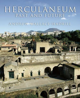
In late August A.D. 79, Mount Vesuvius erupted with deadly force. Ash, stone, and scorching hot dust rained down on the southern Italian cities of Pompeii and Herculaneum, completely entombing the cities and their residents, and providing archaeologists with an unparalleled window into everyday life in the first century A.D. Despite a steady stream of publications and documentaries about these sites, Andrew Wallace-Hadrill's book Herculaneum Past and Future(Frances Lincoln Limited, $60) and Pompeii the Exhibit: Life and Death in the Shadow of Vesuvius at Discovery Times Square in New York City (through September 5), prove there is still room for more.
After 10 years as director of the Herculaneum Conservation Project, there is no archaeologist better suited to raise this city from its relative obscurity than Wallace-Hadrill. His book is filled with hundreds of new and archival photographs, panoramic views, and an invaluable foldout map of the site. The book is arranged in highly readable chapters that focus not only on the history of excavations, ancient city planning, and Herculaneum's vibrant fresco paintings and mosaics, but also succeed in populating those spaces. Wherever possible, Wallace-Hadrill tells the individual stories of slaves, citizens, and the elite, using the enormous wealth of archaeological evidence Herculaneum provides—residents' names, their houses, their furniture and food, and even their skeletons. While its visual appeal may lead readers to believe Herculaneum Past and Future is merely a coffee-table book, the research Wallace-Hadrill presents is comprehensive and of the highest quality. The author has filled a gap in the public's knowledge of Herculaneum—an even better-preserved city than its neighbor, Pompeii, only four miles away.


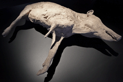
plaster cast of a pig


Among the spectacular artifacts at a new exhibit telling the story of Pompeii is a rarely-displayed plaster cast of a pig that died in the eruption of Mount Vesuvius in A.D. 79.


(Running Subway, William Starling)


People are also the focus of Pompeii the Exhibit: Life and Death in the Shadow of Vesuvius. Unlike most exhibits on Pompeii, there is a refreshing lack of sensationalism about the terrifying experience of the eruption. Visitors are made to feel as if they have entered an ancient Roman home. The exposition space's walls are covered in stunning frescoes and mosaic—most of which come from the House of the Golden Bracelet, one of Pompeii's finest properties. This offers an extremely rare chance to see artifacts of this quality outside of Italy. Inside a large room representing a marketplace, cases are filled with artifacts (some real and some excellent replicas) of everyday life, including kitchen utensils, lamps, and even food preserved by the eruption. The full range of ancient Pompeian life, including religion, politics, and even erotica (which is decorously presented in a space resembling a bedroom in one of Pompeii's brothels), is on display.

What will surely be one of the exhibit's biggest attractions are the 20 plaster casts of Vesuvius' victims, some of which were made in the 19th century, although three were created especially for the exhibit. The casts, made from voids left in the hardened ash, preserve a person or animal at the moment of their death, and remind the visitor that the same volcano that preserved the city also killed thousands. For those new to the archaeology of Pompeii and Herculaneum, both the exhibit and the book provide an exciting opportunity to connect with people who lived almost 2,000 years ago.


[Web] Iz casopisa Archeology : Artifact


Artifact :  Volume 64 Number 3, May/June 2011

[image]
(Courtesy of University of Manchester)


WHAT IS IT?
An artificial toe 

DATE
950—710 B.C. 

MATERIAL
Wood and leather 

DISCOVERED
2,000, tomb of Tabeketenmut in necropolis of Thebes, near Luxor 

SIZE
4.7 inches, from tip of toe to point of attachment

CURRENTLY LOCATED
Egyptian Museum, Cairo
Egyptians appear to have taken great pains to have the bodies of their dead buried intact. Some mummified remains are found with makeshift limbs and false eyes to replace missing parts. This artificial toe, attached to the right foot of a priest's daughter, is so well made, however, it's unlikely it was only intended to prepare her for the afterlife.
The dense hardwood used in the toe's construction is robust enough to withstand bodily forces—while walking, a big toe must bear up to 40 percent of a person's body weight. It also has a beveled edge at its attachment point, indicating it was deliberately designed to maximize comfort, says Jacqueline Finch, a visiting scientist at the University of Manchester's KNH Centre for Biomedical Egyptology. She recruited two volunteers who are missing their right big toes to wear a reproduction of this device along with replica Egyptian sandals. Both reported that it was comfortable and assisted them in walking.
Until now, an artificial leg made of bronze and wood and found buried with a Roman aristocrat in southern Italy dating to 300 B.C. was thought to be the first prosthesis. Finch's work suggests, however, that the Egyptians be credited with pioneering prosthetic medicine.

Monday, May 23, 2011

[Izlozbe] Kleopatrin svet u Kopenhagenu

Cleopatra’s World 29.4.2011 - 7.8.2011 

Cleopatra, Queen of Egypt and lover of both Julius Caesar and Mark Antony, the meeting of East and West! An experience for visitors to the Ny Carlsberg Glyptotek.
The name Cleopatra still has a powerful air of mystery, 2000 years after her death. Cleopatra put herself in the eye of the hurricane and took an active part in the political power struggles with Rome which changed the course of world history.

At the exhibition Cleopatra’s World visitors come face to face with the past. Myth and mystique are presented side by side with historical knowledge.

The exhibition presents art from Cleopatra’s own era and examples of modern, popular depictions of the Queen of Egypt. 


Lectures on Cleopatra’s World   


See upcoming exhibitions...

[Vesti : Zahi] 7 New Kingdom Tombs to be Opened at Saqqara


Tomorrow Dr. Zahi Hawass the Minister of State for Antiquities will open 7 tombs in the New Kingdom Cemetery in South Saqqara for tourism for the first time. This site contains the famous tomb of Maya, who was the treasurer of King Tut, as well as the tomb of Horemheb, the general of King Tut who later became king.
The Ministry is currently in the process of developing a management plan for the Saqqara site. It is hoped that this will enhance the value of the site as a visitor destination through better signage and facilities, as well as promoting local community involvement and an improved security presence.

Maya and Horhemb, were very important men during one of Egypt’s most tumultuous periods, the Amarna Period. During this time, the pharaoh Akhenaten closed Egypt’s most important temples in Luxor and moved the capitol to a site in the middle of the desert called Akhetaten or Tell el-Amarna. He even changed the principal state god from Amun to the sun-disk, called Aten.   When Akhenaten died, his son, one of the most famous kings of Egypt, Tutankhamen, became king. King Tut decided that he would restore order to Egypt by moving the religious capitol back to Luxor, reinstating the god Amun and abandoning Tell el-Amarna. In order to make all of these changes, King Tut needed the assistance of his treasurer and his general.


Maya was King Tut’s treasurer and was essential to restoring Egypt to her pre-Amarna glory. He helped the King to reopen the temples in Luxor as well as build new temples and shrines to Amun to show that King Tut was dedicated to restoring order to Egypt.   Maya was responsible for restoring order in Egypt, while his colleague Horhemheb restored order abroad.  While his tomb was left unfinished, visitors will now be able to see the mudbrick pylon with spectacular relief fragments as well as courtyard images of Maya and his wife Merit, who was also buried in the tomb, receiving offerings. 

Horemheb began building his tomb in Saqqara while he was a general under King Tutankhamen. During this time, Horemheb would have been one of the most important men Egypt and was responsible for the foreign affairs of an empire trying to regain power after the Amarna period.  After the death of King Tut and his immediate successor, Ay, Horemheb became king of Egypt and left his tomb at Saqqara in favor of a more prestigious spot in the Valley of the Kings.    All the hard work on this beautiful tomb was not wasted and his wife Mutnodjmet was buried there at the time of her death. The tomb is built and decorated in the Amarna style art and the interior design shows that it was meant to be a funerary temple.   The details of this tomb, which is the largest in the New Kingdom Cemetery, are fascinating.   When visiting the tomb, visitors can see that the Ureaus, or headdress of the king, was added to depictions of Horemheb after the original reliefs were made to show that he had become King.   There are also depictions of Horemheb worshiping Maat, Re-hor-akhty and Thoth as well as scenes celebrating his military victories. 


 Along with these two famous tombs, five other tombs will also be open to the public:

The Tomb of Meryneith- Meryneith was the Steward of the Temple of Aten and the Scribe in the Temple of Aten during the reign of Akhenaten. After the king’s death, he became the High Preist of Aten as well as the High Priest at the Temple of Neith. His tomb is built of mudbrick encased in limestone blocks. In the very back of the temple there are three chapels for the offering cult of Meryneith. The central one shows a scene of metal workers and the bases of two small columns. A mudbrick pyramid may have originally stood here. 

The Tomb of Ptahemwia- Ptahemwia was the “Royal Butler, One of Clean Hands” to both Akhenaten and his son, Tutankhamen. He was responsible for brining the king food and drink and his tomb contains the prestigious title of “Beloved of the King”. Ptahemwia’s tomb is also mudbrick encased in limestone and contains three chapels. In one of these chapels, Martian and his team found 56 coffins from the New Kingdom. Most of them contained the bodies of children who were affected by disease.

The Tomb of Tia- Tia was one of the top officials under Ramsess II, and was the Overseer of the Treasury. He was married to one of Ramsess II’s sisters, who was also named Tia. Tia’s tomb was also used as a mortuary temple to the god Osiris and contains depections of Tia and his wife making a pilgrimage to Abydos, the cult center of Osiris. 

The Tombs of Pay and his son, Raia- Pay was the Overseer of the Harem under King Tutankhamen. Pay’s tomb consists of a chapel that opened into a pillared court with three offering chapels. Pay’s son, Raia, began his career as a solider in the army, but took over his father’s post after his death. Raia added a courtyard, and two stelae, as well as performed renovations to the tomb before he himself was buried there. The two stelae were brought to Berlin when Richard Lepsius discovered them in 1928. 

Some of these tombs were first discovered in 1843 by Richard Lepsius, but were not fully excavated until an Anglo-Dutch mission began excavating there in 1975. Between 1975 and 1998, the dig was directed by Geoffrey Martin who discovered many of the tombs.  Now a Dutch team from Leiden University, led by Dr.Maarten Raven, excavates at the site and are rediscovering and restoring these amazing tombs.
This meeting to open the tombs will be at 9:30 on May 23 at the entrance to Saqqara. 

For regular updates please follow my official Facebook page http://tinyurl.com/3mm7acq and Twitter feedhttps://twitter.com/#!/ZahiHawass.

[Media : 3D] Rome Reborn 2.1


Rome Reborn is an international initiative to use 3D digital technology to illustrate the urban development of the ancient city from the first settlements in the late Bronze Age (ca. 1000 BCE) to the depopulation of the city in the early Middle Ages (ca. 552 CE). Thus far, the Rome Reborn team has concentrated on modeling the city as it might have appeared in 320 CE when it reached the peak of its development with a population estimated to be ca. 1 million people occupying ca. 25 sq. km. of space inside the late-antique walls and using ca. 7,000 buildings.

An interactive earlier version of this model, called Rome Reborn 1.0 (9 million polygons) has been available at no cost since 2008 in the Gallery of Google Earth, where it is called "Ancient Rome 3D." This present version (October 2010) is called Rome Reborn 2.1. It has over 650 million polygons and still a work in progress. Before being released to the public as an interactive product capable of being explored in real time over the Internet, we need to review and correct the model archaeologically; and find a suitable technology platform for making such a massive model available to Internet users. Work is underway to address both issues.

Meanwhile, we offer this video exploration of the model, which we hope will already be found useful by students and teachers of ancient Roman topography and by the general public.

This video is copyright 2010 by Bernard Frischer. All rights reserved. The 3D models comprising Rome Reborn 2.1 are copyright: 2007 by The Regents of the University of California; 2007 by the CNRS, Bordeaux; 2009 by the Universite' de Caen; and 2010 by Frischer Consulting, Inc. All rights reserved. For additional credits, please see the end of the video.

For more about this project, see: www.romereborn.virginia.edu.

For further information about this video, please write or call the project director, Prof. Bernard Frischer at:

cell: +1.310.266.0183
email: bernard.d.frischer@gmail.com
personal webpage: www.frischerconsulting.com/frischer

[Media:Film] What have the Romans ever done for us ?


from : The Life of Brian

Sunday, May 22, 2011

[Vesti] Pronadjen anticki brod u Ostiji !


(ANSA) - Rome - An ancient ship has emerged from the ground at the Imperial Roman port of Ostia in a find Culture Minister Giancarlo Galan said "gives you goose bumps".

An 11-metre section of one of the ship's sides has so far been discovered, archaeologists said.
They and Galan said the discovery would make experts think anew about the exact location of the port where the Roman empire's biggest fleet was stationed and through which goods travelled to and from the imperial capital.
"This great result tells us a lot of things about the ancient coastline and what was happening about 2,000 years ago," said Galan, who rushed down to the site after the find was made public.
Archaeologists said they were expecting to find something in the area, where a major road bridge is being rebuilt, and had launched a programme of so-called 'preventive archaeology'.
Site director Paola Germoni stressed that this type of work "enables us to combine the demands of conservation of ancient artefacts with the needs of the general public".
She said the discovery "would plausibly move back the ancient coast line some four kilometres from where it is now".
Silt and river movements have pushed back the area of the once-bustling port, which is now a major archeological site called Ostia Antica, the best-preserved ancient Roman town outside Pompeii.
Although it attracts far fewer visitors than Pompeii, many enthusiasts say it offers a similar thrill and feel of ancient life.
Anna Maria Moretti, archaeological superintendent for Rome and Ostia Antica, said "the find is a novelty because at that depth, about four metres below the topsoil, we have never found a ship, only layers (of buildings) and one single structure".
"At the moment we only have a sizeable chunk of one side (of the ship), neither the poop or stern".
She also said there were "remains of ropes and cables" in the ship.
"Restoring the vessel will be an extremely delicate operation," Moretti went on. "We're keeping it constantly covered in water so that the wood doesn't dry out.
"The wreck must be treated with highly sophisticated preservation techniques," Moretti said.
Several Roman ships were found during the construction of the nearby Fiumicino Airport in the 1950s and are now housed in a museum at Ostia Antica.
Ancient Roman Ostia, at the since-moved mouth of the River Tiber, was built into a massive complex under the Emperor Claudius and given the name Portus, meaning port.
It was expanded under successive emperors such as Trajan and Hadrian and served as a base for many of the empire's greatest expeditions.

Ostia was also the depot channelling the vast wealth, grain and other supplies needed to feed the appetites of the imperial city.

[Vesti] Otkriveno rimsko pozoriste u Kenterberiju

Canterbury’s Roman Theatre has once again taken centre stage. Routine investigations at the north-east end of Castle Street, revealed a section of paving that probably formed part of the orchestra, together with masonry possibly associated with the stage.


Slabs in base of trench. ©CAT Ltd

Blocks of tightly-jointed, squared blocks of greensand were found in the first trench (0.10m in thickness and on average measuring about 1 by 1.20m) and were laid over a thick bedding of mortared flints.
The second trench, crossing Castle Street, contained a large water main cut through solid flint masonry bonded with a tough Roman mortar. The masonry appeared to have been laid as a mass foundation at a key point of intersection between perhaps a stage, the edge of the orchestra, the lowest tiers of banked seats and the additus maximus, a wide, paved passage that linked the orchestra to the principal entrances and exits to the theatre, located either side of the stage.  A further section of the flint foundation was capped by a footing of three courses of Roman bricks perhaps forming either part of a rib wall supporting the stage or possibly a remnant of the front wall of the stage.

Fragment of roman foundation and brick courses in pipe trench. ©Canterbury Archaeological Trust Ltd

 The earlier theatre reconstruction ©Canterbury Museums

The Roman civitas capital of  Durovernum Cantiacorum was laid out for the first time in the Flavian period (AD 70–80), and the first theatre was built around AD 90, with seating supported by a gravel bank retained by masonry walls. The theatre may have been built to link with a pre-existing temple precinct, the two monumental structures separated by a wide street (perhaps the cardo) but forming perhaps parts of a single complex. A further major episode of town planning in c AD 110–20, led to the development of forum, basilica, public baths and a new temple precinct, surrounded by a temenos with internal facing portico. The central temple has yet to be located.
The theatre was rebuilt in stone and brick on a monumental scale in c AD 210–20 and it is part of this building that has been exposed at the end of Castle Street. It was a colossal building for Roman Britain (a modest structure compared with similar developments in other provinces), perhaps too large an undertaking for local money to have paid for without help from the Roman state. In AD 208 the African Emperor Septimius Severus (a native of Lepcis Magna near Tripoli in Libya) was campaigning in the north of Britain – he died in York in AD 211 – and, although there is no evidence to support the theory, perhaps Septimius or his son Caracalla sponsored the development.


Reconstruction drawing of Canterbury theare during the Roman period. ©Canterbury Archaeological Trust Ltd


The building was D-shaped measuring some 75m across the back of the ‘D’ and 57m from the back of the stage (the scaenae frons) to the outer edge of the external curving wall. The height of the theatre is difficult to gauge, but perhaps it rose to 25m above the orchestra, dominating the skyline of the Roman town. Two great curving walls separated by an opus signinum paved passage formed the cavia, supporting the upper tiers of banked seats overlooking the stage (pulpitum) and orchestra.
Fragments of both curving walls have been located in service trenches since 1868 in Castle Street, Watling Street and St Margaret’s Street and since 1950 in the cellars of a number of properties. Other internal footings for symmetrically-placed radial passage walls leading from the cavia to the orchestra, for possible staircase foundations and for a series of curving walls (caissons) built to retain the gravel bank of the previous theatre and support the tiers of seats, have also been located in excavations or during service trenching.
This new section of the theatre is the most significant discovery since Professor Frere’s excavations under No 3 Watling Street in 1950 and 1951 and provides us with key evidence to check the alignment, the relative levels of the cavea pavement and the orchestra, the south-west edge of the orchestra and the stage position.

Post Roman deposits

Of equal interest and importance are successive post Roman deposits of street metallings that cap the surface of the pavement and a series of early south-west to north-east aligned wheel-ruts worn into the surface of the orchestra. The ruts and metallings represent the formation of perhaps one of the earliest Anglo-Saxon streets within the walls, the predecessor to Castle Street.

Cart ruts in the stone slabs. ©Canterbury Archaeological Trust Ltd

The street appears to have been aligned to access the theatre through the additus maximus and perhaps extended right across the orchestra, either to follow the line of a lost lane a continuation of which survives today as Picknot Alley north-east of St Margaret’s Church, or to exit the theatre through the northern radial passage wall to follow St Margaret’s Street.  The original line of Roman Watling Street ran well to the south-west of the theatre (following the line of present Adelaide Place) running along the south-west side of the temple precinct.

Anglo-Saxon period

By the Anglo Saxon period a new Watling Street was realigned to enter the theatre perhaps through the south-east radial passage wall and across the orchestra and through the former scaenae frons (which was originally provided with stage doorways) to follow the line of Beer Cart Lane. It is even possible that this street was aligned to pass through a pre-existing opening connecting theatre and temple.
The new evidence therefore throws some extra light on how the old Roman theatre continued to dominate the skyline and influence the developing topography of the town, with new streets leading to a place of refuge, assembly, even a market place in the early Anglo-Saxon period and in later years into one of the largest quarries for building stone within the old Roman walls.

Canterbury Archaeological Trust would like to thank South East Water for the very positive and helpful way they have responded to this exceptional discovery.